Our Home

Our Home

Sunday, July 9, 2017

Selkirk Loop - British Columbia

We took a three day trip into British Columbia to complete the International Selkirk Loop and two of the Super Side Trips on the Canada side. We made the Best Western Plus in Nelson, BC, our home for two nights. This small artsy town, on Kootenay Lake, was conveniently located at the junction of the two super side trips that we planned to travel.
Box Canyon Dam south of Metaline Falls, Idaho

Lunch at Kootenay Pass (5,820 feet)
In Stagleap Provincial Park on
Canada's Highest Year Round Highway

Glass House in Boswell, BC
constructed of more than 500,000 discarded
embalming fluid bottles.

Pilot Peninsula Lighthouse

Climbing the steep lighthouse stairs.

Beautiful View of Kootenay Lake


Highway 3A requires a 45 minute free ferry crossing of Kootenay Lake. This was a very scenic boat ride and quite a deal for the price.

Two ferries kept the schedule right on time.


The two ferries pass at the half-way point.
Silvery Slocan Super Side Trip
Monday morning we headed northeast out of Nelson along the Kootenay Lake shore. In our opinion, this turned out to be the most beautiful of the six Selkirk Super Side Trips. Lots of snow capped peaks and abundant wildflowers along the roadside.
Our first stop was Ainsworth Hot Springs and Caves.

View from the hot spring pool deck.

Hike to Fletcher Falls
near Mirror Lake
We stopped in the charming village of Kaslo for a self guided tour of the SS. Moyie a Canadian National Historic Site. This is the world's oldest intact passenger sternwheeler. Built in 1898 for the Canadian Pacific Railway, the Moyie steamed on Kootenay Lake until 1957. This method of travel was very important due to the lack of roads in this area at the time.
SS. Moyie carried passengers and freight for 57 years.

Pilot House and Texas Deck (top)

Pantry on Board
Hot food was prepared on the deck below in
the Galley and transferred via
a dumb waiter in the center above.

Ladies Saloon

Pilot House

17 Foot Paddlewheel

1940 Canadian Pacific Railway Caboose.

Riding the rails

View of Kootenay Lake from the Texas Deck

Ever Present Flowers Gracing the Roadway

Stopped at the mining Ghost town of Sandon.

The little power plant is still generating
2300 volts of hydro-electric power.

They sell their electricity to BC Power

This is what is producing the power. The water
will eventually join the Columbia River,
flowing through 12 more hydro-electric dams. 
Our last stop of the day was in the town of New Denver to visit the Nikkei Internment Memorial Centre. This is a memorial dedicated to the memory of the 22,000 Japanese Canadians interned during World War II.

Most internment camps were destroyed after the war,
this is one that was preserved.

Slocan Lake and Valhalla Provincial Park  
Rivers, Dams and Mines Super Side Trip
Tuesday we left our hotel in Nelson and started our drive back to Idaho taking our final Super Side Trip. We stopped in the Russian village of Castlegar. It is located at the confluence of the Kootenay River and the Mighty Columbia.
Suspension Bridge to Zuckerberg Island
In Castlegar, BC

Home of Alexander and Alicia Zuckerburg

Wednesday, June 21, 2017

Selkirk Orchards Loop and CDA Scenic Byway

We had a string of perfect weather, so we decided to take a couple of scenic driving tour loops. Monday heading north into British Columbia we traveled around the Selkirk Orchards Galore Super Side Trip. Tuesday we drove the Lake Coeur d' Alene Scenic Byway which took us south around this beautiful lake.
 
Selkirk Orchards Galore Super Side Trip
This 50 mile side trip off the Selkirk Loop starts north of Bonner's Ferry. We stopped at the Moyie Crossings National Forest Picnic area just south of Good Grief, Idaho. This beautiful park sits atop a hill overlooking the Moyie River.

The sculptures and picnic grounds were donated by
Pacific Gas in return for gas line
right of way.
Just before we crossed the border into Canada, we took an interesting one mile loop trail which included the Copper Falls Overlook. Copper Creek plunges 150 feet over a cliff, forming the Copper Creek Falls. It is one of the tallest falls in Idaho. The falls freeze solid every winter and offers ice climbers a great opportunity to practice their skills.
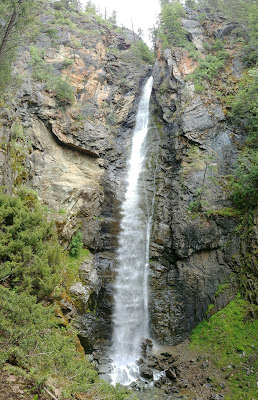
Copper Creek Falls

The trail meanders back and forth across creeks.
After viewing some beautiful scenery from the car, we stopped in Creston, BC, hoping to buy some fresh strawberries. They had already sold out for the day, so we bought some fresh asparagus instead. It is still early in the year, maybe next time.
Lake Coeur D'Alene Scenic Byway
Beginning at the junction of Interstate 90 and Idaho 97, the route travels south along the eastern shoreline of Lake Coeur d’Alene, and ends at Idaho 3, where it meets the White Pine Scenic Byway. Almost the entire 35 mile byway hugs the cliffs along the edge of the lake, allowing great viewing of the lake and elite lakefront homes. We watched a number of Western Grebes on their nests near the Thompson Lake Idaho Fish and Wildlife Refuge.
Lake Coeur d'Alene

Overlooking a small arm of the lake.
I-90 bridge in the distance.

Tuesday, June 13, 2017

A Day in Wallace, Idaho

Entering the Silver Valley, just west of Wallace, we stopped at Old Mission State Park in Cataldo, Idaho. The Mission is the oldest historic building in Idaho. It played a key part in the development of the Northwest. It was begun in 1850 by Jesuit Priests and members of the Coeur d'Alene Indian Tribe. The Coeur d'Alenes heard that the neighboring tribes had a "medicine man" of great powers, so they welcomed the "Blackrobes", Catholic Jesuit priests among them.

The altar and paintings were all hand carved by
Father Antonio Ravalli. 

The Parish House stands next to the Mission.
Wallace, Idaho, is America's only city entirely listed on the National Register of Historic Places. Since 1884 over 1.3 billion ounces of silver have been mined here, $90,000,000 in the last 12 months alone. This area is the richest silver district on the planet, hence the name "The Silver Capital of the World." The city was also extremely well known for booze and brothels, the last one closed in 1991.

Wallace is famous for having the very last traffic signal along Interstate 90 which runs between Boston and Seattle. The reason for this was the highway commission wanted to bulldoze the entire town to make room for I-90. The town said "no" and held up the project in court for 17 years, in the meantime establishing the whole town on the National Register. This resulted in creating an elevated portion of the highway passing over Wallace, at an additional cost of $43 million.

SUNSHINE MINE DISASTER
On May 2, 1972, fire broke out in the Sunshine Mine, carbon monoxide, heat smoke and gas spread swiftly through the tunnels. Ninety-one miners perished in the country's worst hard rock mine disaster since 1917. The Sunshine is the largest silver mine in the nation at a mile deep it has 100 miles of tunnels.
Sunshine Mine Memorial

Main Street Wallace

The Center of the Universe
Well really its in the Center of Wallace.

Thought we would take an underground mine tour.

The mine tour included a trolley tour of Wallace.

Hard Hats on and Ready to Go

The guide, a retired miner, demonstrated mining tools.

We took a drive up Burke Canyon to visit the ghost mining town of Burke. The canyon was so narrow that mines, mills, railroad and even the hotel had to share the same thoroughfare. The hotel, the Tiger, made Ripley's Believe It or Not for having a river, road and 2 railroad tracks passing through it.
Picture of Burke, Idaho in its Heyday

Wednesday, June 7, 2017

Flowery Trail - Little Pend Oreille NWR Super Side Trip

Traveling further west we drove to the town of Tiger, Washington, and took Highway WA20 to US 395 to Flowery Trail Road. Our first stop was at a beautiful National Forest Campground in Colville National Forest for lunch. The place was deserted so we took one of the premo campsites for lunch.
Little Pend Oreille Lakes
Crystal Falls
named for their appearance in winter,
is just east of the NWR.
Little Pend Oreille National Wildlife Refuge is named for the river that flows through its northern expanse. We spent a couple hours driving the 10 mile gravel tour road through this 40,000 acre refuge. This is the only mountainous, mixed-conifer forest refuge in the NWR system, outside of Alaska. This place is way out there, there is no cell phone service.
Barn remains from the 1890's Homestead
that once occupied a portion of the Refuge.
Auto Tour Overlook at Lake McDowell
We stopped at the Keller House Museum
In Colville, WA, but it was closed for the day.

South Lakes and Priest Lake Super Side Trip

Another beautiful day and another Super Side Trip from the Selkirk Loop. We drove west from Farragut State Park to Spirit Lake, then north to Priest River and Priest Lake. Our first stop was at the Albeni Falls Dam. This hydropower, Army Corp of Engineer dam was built in 1955. The Albeni Falls was replaced by the dam to generate electricity. Lake Pend Oreille (pronounced Pondoray), literally translates "hanging ears." This name was given to the area Indians by French Canadians. The lake flows into the Pend Oreille River, passing the dam and then on to the "mighty" Columbia River and out to the Pacific. Lake Pend Oreille at 68 miles long, has over 226 miles of shoreline and has a maximum depth of 1,237 feet.


We stopped for lunch at Priest Lake State Park and "enjoyed" a MRE (meals ready to eat) complements of an ROTC group who stopped for a tour of the Museum at the Brig. Needless to say, we did have an early dinner that evening.

Priest Lake State Park lies just 30 miles south of the Canadian Border. It is nestled deep below the crest of the Selkirk Mountains. It was very quiet when we stopped by there Tuesday, the day after Memorial Weekend.


Priest Lake
Indian Creek feeding Priest Lake was fast
flowing due to the heavy winter snowmelt.