Our Home

Our Home

Friday, July 29, 2022

Arches, Arches, Arches, Dam

With all the sandstone, there has to be arches. We picked up a brochure that gave directions to many of the little-known arches around Aztec, New Mexico. The arches are located via oil and gas lease unimproved dirt roads. There are no signs or postings for the arches, so, we went on a hunt to find some of them.

Arch Rock

Arch Rock is about seven and half miles off the paved highway.
Kurt hiked around the deep ravine so he could be up close and personal.

UFO Landing Site

Some people believe that on March 25, 1948, a spacecraft crashed on this mesa. A high security recovery operation removed the remains and took them to Los Alamos Laboratory for study. It was reported the space craft was about 100 feet in diameter and eighteen feet tall. All the occupants, maybe 16 total, died in the crash. 
Since the crash site was close to Arch Rock we stopped but saw no evidence.
This boulder near the crash site, looks like a statue of Alf, the alien, from the 1980's sitcom of the same name.

Burns Arch

Peephole Arch

Keyhole Arch

We found this arch directly below Petroglyph Arch.

Petroglyph Arch

Rooftop Arch


Navajo Dam

The construction of Navajo Dam began in 1957 and was complete in 1962 forming Navajo Lake. We saw two active osprey nests around the dam.
The Navajo Dam impounds the San Juan River.
The earthen dam is 3,648 feet wide and 402 feet high.
The water is mainly used for local irrigation and recreation.
Navajo Lake Marina
Downstream from the dam, fly fisherman were along the San Juan River in Navajo Lake State Park.

Thursday, July 28, 2022

Puebloan Ruins Around Bloomfield, New Mexico


Aztec Ruins National Monument

From the late 1000s to the late 1200s, people known as ancestral Puebloans planned and built this settlement near modern day Aztec, New Mexico. The first dwellers were influenced by Chacoan architecture, ceramics and ceremonial life. It became a National Monument in 1923 and a World Heritage Site in 1987.
These structures were not built by the Aztecs. This name comes from the Spanish maps of the 1800s.
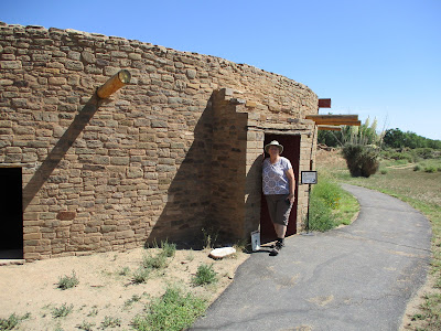
The Great Kiva was a central gathering place for ceremonies and community events.
This Great Kiva was rebuilt on the original foundation in 1934 to show us how they were constructed.
This was rebuilt using modern day construction. The original wood pillars sat on large stone disks.
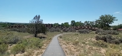
Aztec Ruins is one of the more intact Puebloan settlements.
The thick tapering walls of the great house had a core of roughly shaped stones and mud mortar between sandstone masonry exteriors.
This is one of the taller doorways.
To travel between rooms, they passed through short doorways. This series of rooms is still roofed with 900-year-old beams.
The complex covers a two-acre site.
The three-story buildings had over 400 rooms and many kivas.
The Visitor Center/Museum were directly in front of these ruins.

Salmon Ruins

Only three miles from "home", the Salmon Ruins are preserved, owned and operated by the San Juan County Museum Association.
Beginning in the late 11th century, people from Chaco Canyon came to the banks of the San Juan River to build the great house community now referred to as the Salmon Ruins.
The veneer of the walls is similar to the Chaco Canyon Great Houses, with noted differences. The vertical mortar had small flat stones as well as the horizontal.
This was called an elevated great kiva because it sat above the great house.
Adjacent to the Salmon Ruins is the homestead of George Salmon. He purchased this land and preserved the ruins within his ranchland. This is the bunkhouse.
George Salmon's main house.

Bisti Wilderness and Four Corners Monument

After spending two weeks at Cochiti ACE Park, we traveled to the northwest corner of New Mexico. We made Bloomfield our home for a week. 

Bisti/De-Na-Zin Wilderness Area

Bisti Wilderness lies on Bureau of Land Management Land and is largely undeveloped. We discovered many interesting formations but found only primitive roads and no formal trails. Overall, this reminded us of Badland National Park in South Dakota.
This 45,000-acre wilderness area was established in 1984.
Bisti Wilderness is surrounded by tribal lands.
There was no one around. The only sound was the wind. Now we feel no need to experience Mars.
Many dinosaur bones and petrified wood have been unearthed here.
Conservatively, we did not wander beyond the site of our Ranger.
The wind and rain sculpted the land beautifully.

Four Corners Monument

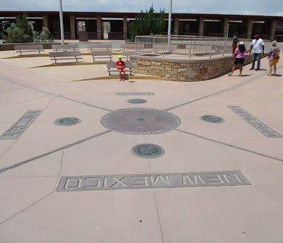
Following our adventure to Bisti, we took a short road trip to the Four Corners Monument. We knew this was touristy, but it is something we wanted to do once.
Desolate Area.
After paying our $16.00 entrance fee, we walked around for about 10 minutes.
There was a very long line to take turns posing and having your picture taken on the monument.
Kurt just casually walked through the center between picture takers, and we grabbed a quick photo.

Shiprock Peak

On our way "home", we stopped at Shiprock Peak as a late afternoon mountain shower was approaching. This is on tribal land and has no paved roads to reach it. It is considered sacred, and no direct access is permitted.
This peak is 1,536 feet above the desert floor and is a National Natural Landmark.
The rock is a lava neck, similar to Devil's Tower in Wyoming.